KapLogic Aegis Advances Security Operations with Enhanced GIS Mapping Integration
Colorado Springs, CO — March 24, 2026
KapLogic Corporation today announced significant enhancements to its Aegis security orchestration platform, introducing advanced Geographic Information System (GIS) mapping capabilities that provide enterprise security operations with unprecedented spatial awareness and real-time asset tracking across distributed facilities.
The new GIS mapping integration transforms how security teams visualize and respond to incidents by replacing traditional static floor plans with dynamic, geographically accurate map representations. This advancement enables organizations to monitor and coordinate security operations across multiple locations, cities, and regions from a single unified interface.
Key Capabilities
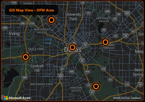
Expanded Mapping Capabilities – The System of Record
Aegis now serves as the authoritative spatial reference for security infrastructure, providing a more versatile and geographically accurate representation of the security environment. Organizations can visualize assets, personnel, and incidents in their true geographic context, enabling better strategic decision-making.
Location-Aware Icons – Strategic Alignment
The system supports real-time updates of icon locations within the GIS mapping interface, enabling Aegis to track assets and personnel dynamically. Security teams can monitor the movement of guards, vehicles, and mobile assets as they respond to incidents, providing complete situational awareness across distributed operations.
Simultaneous Map Display – Inter-Agency Utility
Aegis can be configured to display both GIS and Computer-Aided Dispatch (CAD) maps simultaneously, providing a richer visual context for security events. This dual-map capability allows operators to correlate spatial data from different sources, facilitating seamless coordination between internal security teams and external emergency response agencies.
“Geographic context is fundamental to effective security operations,” said the KapLogic development team. “By integrating enterprise-grade GIS capabilities into Aegis, we’re giving security professionals the same spatial intelligence tools used by emergency services and military operations. This enables them to make faster, more informed decisions when every second counts.”
Multi-Site Enterprise Applications
The GIS mapping enhancement is particularly valuable for organizations managing security across multiple facilities, campuses, or geographic regions. Security operations centers can now monitor and coordinate responses across locations spanning multiple cities or states, with each site’s security infrastructure accurately represented on a common geographic platform.
The system integrates seamlessly with existing access control, video surveillance, alarm monitoring, and incident management functions within Aegis, ensuring that all security data is spatially referenced and immediately accessible to operators.